

SNOWSHOE RENTALS in qathet, B.C.
Snowshoes rent for $25 / day or $35 / 2 days
Telescopic Poles rent for $4 / day
Gaiters rent for $3 / day
We don’t hold store hours so you can pick up super early, and drop off late!
ALL RENTALS ARE PER CALENDAR DAY (NOT 24 HRS)
price does not include 7% PST or 5% GST
Credit Card Surcharge - A surcharge of 2.4% will apply to all credit card payments.
Alternatively, you may wish to pay by WISE or eTransfer to: info@canoeingbc.com which will not incur a surcharge.
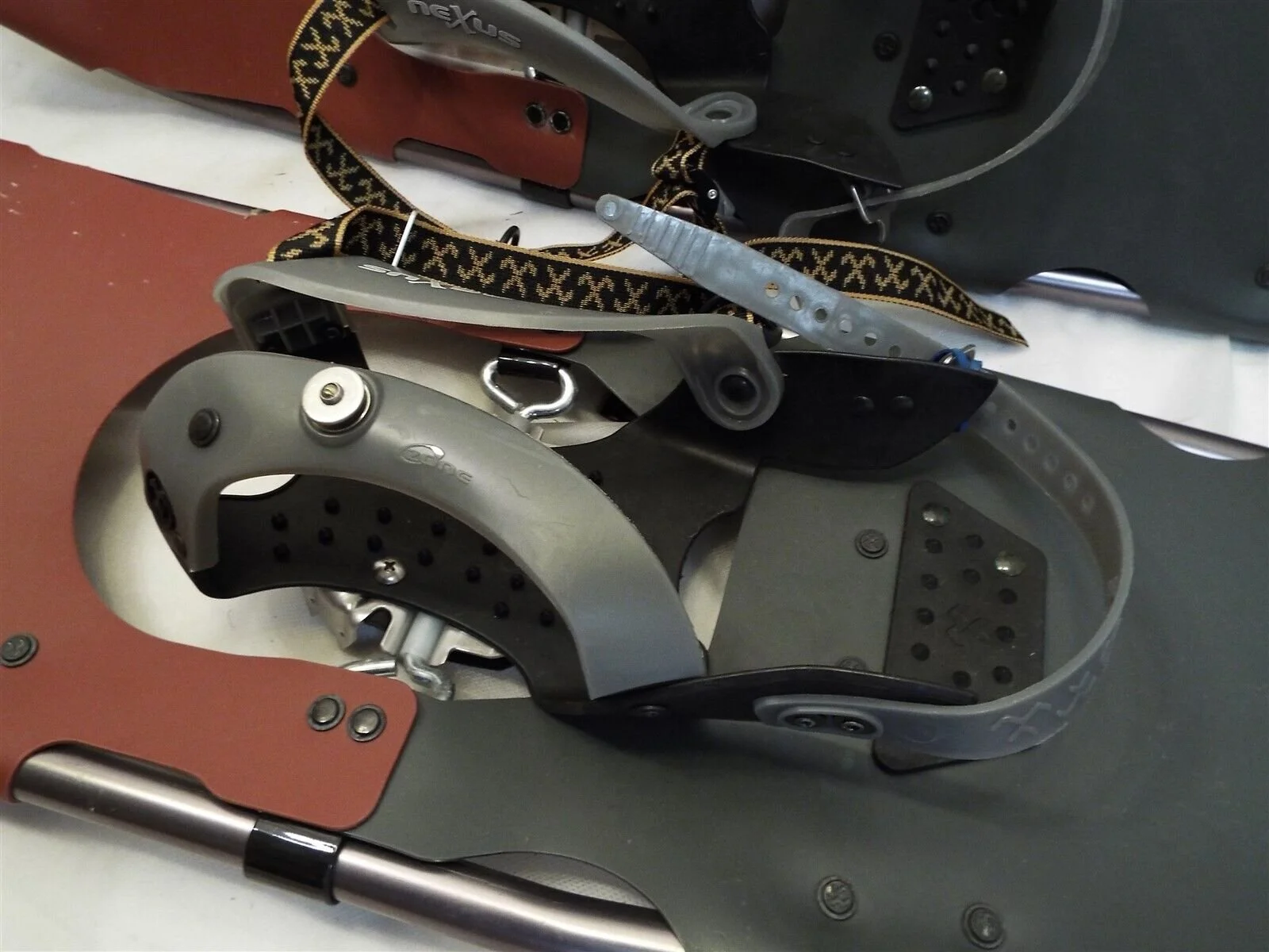
We rent lightweight, top-of-the-line AXLE shoes with full oval frames (not U shape). They have tough ArcTec full-coverage decking for high flotation, fast snow shed and great lateral stability.
They are comfortable, easy to walk in and stay on!
Axle pivot points are superior to a rubber strap because they work with the natural flexion of the feet. Full rotation (axel shoes) enable Tail Glide so snow sheds off the tail creating zero resistance where rubber strap shoes force you to lift the weight of the snow rather than letting the shoe slide out from under it. Keep in mind, we have heavy, wet snow here. Lastly, rubber strap shoes flip snow up against the back of your legs and rear.
Full rotation (axel shoes) also allows for maximum crampon penetration, and these Tubbs talon crampons provide constant penetrating contact and maximum grip with their jagged (minimal flat surface) construction and multi-directional orientation. They have aggressive teeth under the forefoot to cope with steeper, icy sections.
A well designed binding is critical
Our precision bindings forefoot harness securely holds the foot without creating pressure points like entry level toe box’s. Tubbs also incorporates their unique OZone construction that keeps the midfoot securely and comfortably in place, and their patented control wings center and hold the heel.
If you use a low quality binding, it won’t hold your foot snuggly in place, your snowshoes won’t track straight and you will constantly be tightening and readjusting the fit: NOT FUN when you are layered up with gloves.

We rent 30”, 25” and 21” depending on the snow conditions and the users total weight (with gear). We also rent women’s bindings (more tapered at tip & tail) so those with smaller feet do not slip out of their binding!
Kids use & love the 21” shoes too. They have a positive experience because the shoe stays on.
Picture yourself snowshoeing on an old logging road blanketed in snow . . . .


Ascend & descend in one day, or spend the night in warmth and go on day excursions from there.
We are very fortunate to have two free-use cabins in the Knucklehead Mountain Range in qathet, BC.
“Throughout history, humans have used snowshoes out of necessity to hunt, trap, travel and socialize. They were lifesavers in fierce winter weather and provided access to remote backcountry wilderness. High country and bush pilots carried them on rescue missions and just-in-case. Made of wood and leather, snowshoes were wide, long, and sturdy, but heavy and difficult to maneuver. The image of the typical snowshoer was the big burly ‘Nanook of the North’ man.”
DRIVING DIRECTIONS TO THE KNUCKLEHEADS
From Highway 101 turn North (away from the ocean) onto Dixon Rd (across from Lang Bay Store).
(If traveling from Saltery Bay Ferry Terminal, travel approximately 12 km (7.5 mi) and turn right onto Dixon Road).
Dixon is a paved road that turns into a gravel road. Drive this for 5 km (3 mi), and go left at the stop sign, onto Goat Lake Mainline, (Lois Lake is on your right). You will see mile markers starting at “4”. Just before 9 mile, turn right to descend Tin Hat Junction, then take first left (shortly after) onto Stillwater Mainline. Go past Horseshoe River, past Freda Creek. Keep left at the Third Lake Road Junction near Mile 13 (to stay on Stillwater Mainline). Go up the hill.
If you’ve hit the fish farm, you’ve gone too far.
“A” branch and “E” branch roads are labeled as they are developing new roads off the main all the time.
***KEEP IN MIND*** The public is not permitted to use these logging roads 6 am to 6 pm, weekdays. To know where you can go and how to use the roads, you can purchase the "Weyerhaeuser TFL39 Block 1 Upper Sunshine Coast Recreation Map" for $5.00. Email: tourism@discoverpowellriver.com or call 1-877-817-8669. You can also monitor the current road use here or call the automated 24/7 Road Access Hotline at 1-604-485-3132 to get the most up-to-date road info.
The logging roads are gravel with potholes. You’ll encounter “cross-ditching” once you’re on “A” or “E” Branch. A four-wheel drive vehicle with good clearance is highly recommended. Make sure you have a full tank of gas too.
BE MINDFUL not to drive up too high. Conditions can change QUICKLY. If it snows while you’re up there, you might get stuck. If it warms, the slush can be dangerous to drive in.
DRIVING TO "E" BRANCH
Keep going straight past “A” Branch, another bridge, then turn right onto "E" Branch at Mile 16. Drive for 3.25 km (2 mi) to the junction of "E" branch & "E100", stay to the right and after approximately 1.5 km (1 mi) you will come to a locked gate. Park off the road, so as not to make it hard for other vehicles to turn around. If you can only drive as high as E100, it’s an extra hour’s (3 km) hike to the trail head.
NOTE** This portion of the road is used as a ski trail so motorized users should respect that when there is snow on the ground.
HIKING INTO "E" BRANCH
It takes about 1.5 to 2.5 hours of uphill hiking on an old logging road from the trail head. It’s not easy to ski up/down the path to the bowl, as it has a lot of cross ditching; some are quite deep.
Once in the bowl, you’ll go right, over a small aluminum bridge, then soon traverse up the bowl. You’ll find yourself heading west again and come upon an intersection. Don’t do the flat trail. Take the uphill road to the left. The cabin is about 15 minutes ahead.
"E" BRANCH CABIN
This cabin is located in the Knucklehead bowl at approximately 3200 ft. An outhouse, without a door, is located about 100 feet northeast from the cabin. A room with a view.
HISTORY OF "E" BRANCH CABIN
In 1959 the ski club was formed by about 12 families. Freda Mountain was mistakenly believed to be Mount Diadem, so all club correspondence stated Mt Diadem Ski Club. The club dissolved in 1977 because of constant irresponsible abuse, vandalism and then the lodge (32’ x 40’) was burnt down.
In 1997, 20 years later, the old Mount Diadem Ski Club #1 rope tow shed (12' x 18') would start to be converted into the winterized cabin, we now have, by the “Knuckleheads Winter Recreation Association”.
FuN FACTS
The club charged $20 /family, $15 /adult, $10 /student under 18 membership, which gave reduced rates on tows, etc.
There were lessons and junior races conducted on the #1 Ski Run.
The club used to hold an annual “Ski Ball” that raised quite a bit of money.
Once, Black Bear got inside the lodge, spilled paint and escaped through the window when he heard people approaching, leaving a trail of white foot prints.
An empty water can used to be left at “Watercan Junction”, to be filled during trips up to the lodge, which is how it got it’s name (where E Branch crosses Alpha Creek).
Cannonball Run (the slope just below Watercan Junction), was named after John Cannon.
DRIVING TO "A" BRANCH
It is on your right at Mile 15.5. When road levels off, you will see “A Branch” marker. You will then take your 4th left.
1st left: it’s a new road (under the power line)
2nd left: is A521. It’s not drive-able, but great snowshoeing to cabin. It’s shorter, but steeper.
3rd left: is A700 slash, which people snowmobile & ski in.
4th left: Shortly after A700, is A900. Take this.
There was a gate here (to promote non-motorized use), but it was vandalized. Now, the plan is to de-activate by cross ditching.
It’s about a 1-1.5 hr hike (2.5 km) hike to A900 if you can’t drive “A” branch at all.
HIKING INTO "A" BRANCH
From below the gravel pit, the hike can take 3-4 hours. You will have more success skiing/snowboarding out from this cabin because there currently isn’t cross ditching.
"A" BRANCH CABIN
It is located about a mile from “E” branch cabin. It has a magnificent view from its upper deck overlooking the Stillwater area. The outhouse is beside it.
Behind this cabin is a large open area known as “The Playground” & “The Lunch Spot” & “Pond Peaks”, which are favorites for snowshoers who know the area. We do not recommend people venture away from the cabin unless they are with someone who knows the area.
HISTORY OF "A" BRANCH CABIN
The “A” Branch cabin was built by Ron Diprose, Jeff Mah & Randy Mitchell, whom were the directors of the Knucklehead Society. Jeff & Ron got the Rotary Club’s interest, who helped fabricate this cabin to lock up. Money also came from The City of Powell River, Forestry and local building supplies & other small businesses contributed. It took Ron, Jeff & Randy 18 weekends to build & furnish.
WHAT'S IN THE CABINS
Each cabin can accommodate up to 8 people for overnight stay. The cabins are closed in, insulated and have a pellet stove for heat. The wood pellets supply is usually adequate. A picnic table has been built inside the cabin for dinner seating arrangements. There is a propane cook stove and a white gas lantern. The sleeping area is the loft. The basement crawl space is used for storage.
There is no need to reserve the cabins, they are unlocked: first come, first served. You're expected to share the space.
USING THE PELLET STOVE
Instructions are posted. You must read through. Do not pour too many pellets in or too fast. Only use pellets. No twigs or paper. PLEASE BE AWARE that you need to bring your own fire gel for the pellet stove. Also, the cook stove and lantern’s take the 2.5 Ibs spin on propane bottles.
Wood pellets are donated by individuals (like you) or the Forest Services. In the summer, volunteers put the time & effort into packing the pellets up for our warmth during the snow season.
It is greatly appreciated when users leave a donation towards pellets & cabin maintenance of “A”, “E” & Emma. A pellet bag costs $10. You can either donate at the local Tourism Center or at our shop. Cash or a cheque made out to Knucklehead Winter Recreation Association is acceptable or buy a Knucklehead bumper sticker for $2 from the Knucklehead Society. Email: KWRAPR@gmail.com
WHAT TO BRING
Everything you would typically bring on a snowshoe excursion. Only a heated shelter is being provided for you ... camera, sunscreen, first aid kit, flashlight, sleeping pad, sleeping bag, food, dishes, cutlery, pots and pans, & propane cartridges (the spin on green ones) if you want to use the cook stove provided, but safer to bring your own stove just in case the one provided doesn’t work. Bring enough water for the hike, but then you can melt snow once at cabin.
Please respect the cabins and leave as found. To ensure the pristine nature of the area please do not cut trees.
Pack out all garbage/canisters as there is no pick up service to the area. Please do not throw diapers down outhouse. Also, do not feed your dog from the cabins pots/dishes because we can’t properly wash things unless water is boiled.
It’s wonderful when people bring extra supplies to leave behind. Suggestions are gel fire starter, candles, dish soap, lighters & good ol’ TP.
Don’t forget to make an entry in the cabin’s logbook too.
Make sure you get an early start so you aren’t descending in the dark.
TOBOGGANING AROUND THE CABINS
There is great tobogganing at both “A” & “E”. Bring your sleds. Yes, there used to be a few at the cabins, but because of a select few, they are no longer there :(
SKIING & SNOWBOARDING AT THE CABINS
There are no clear areas to accommodate this, but when we have lots of snow, areas present themselves.
IS THERE A HIKING PATH BETWEEN "A" & "E" BRANCH CABINS
Yes, part of it is called the “Jeff Mah Trail”, “Cougar Pond”, and it includes various other sections, but it is not well marked.
SNOW CONDITIONS
The elevation of the subalpine area falls within the Coastal Snowbelt. Typically, snowfall begins around November and continues till May. The north slope of the range remains sheltered from the sun; snow can stay on the ground until as late as June. Snow depth ranges from 10 to 18 feet at the peak season in January.
KEEP IN MIND** Blazing trail can be exhausting (change off lead person frequently). Always be prepared to dig out the cabin / outhouse.
ARE AVALANCHES AN ISSUE
You don’t have to be concerned about avalanches if you are below the tree line. Avalanches can occur in “E” branches bowl, also known as the “Valley of the Crescent Moon”, but “A” Branch should be fine. You should be concerned if you are hiking Alpha, Beta, Gamma Lakes or Pond Peak.
FYI
The lands are actually a leased area of crown land (it is not designated parkland but a provincial recreation area, meaning it is not subject to the same rules as parkland; other uses of the area can be developed and changed as required). Located at an elevation of between 5500 and 5300 ft with the ridge extending in a westerly direction, the recreation area is approximately 3 miles by 2 miles (unofficial) of gently sloped terrain. The area is part of a provincial working forest, where a portion has been logged and replanted. The clear-cut areas and old logging roads are very suitable for winter activities.